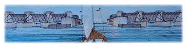
Boston North Shore Study Area

Regional Saugus River Floodgate Project - Everett, Lynn, Malden, Nahant, Revere and Saugus, Massachusetts

The Study and Project
Regional Saugus River Floodgate ProjectSUMMARY

The Boston North Shore study area includes the cities of Revere, Lynn, Malden and Everett, and the towns of Saugus and Nahant, Massachusetts which would have been protected by the Regional Project, previously widely supported by the communities.  The Regional Saugus River Floodgate Project is the primary option for regional coastal flood protection for these communities which was selected:  after detailed investigations of alternatives (1985-1990); overwhelming support by communities; sponsored by the Commonwealth; authorized for construction by the US Congress; but then placed on hold in 1993.  The Boston north shore study area now needs an updated Feasibility study by the US Army Corps of Engineers to re-evaluate the alternatives including the Regional Project as requested by the communities. The study is being called the "Saugus River Coastal Storm Risk Management Feasibility Study" and would be cost shared 50/50 between the Federal Government and Commonwealth of Massachusetts when funded. The Regional Project is a coastal flood protection project which would provide a very high level of protection against accelerated sea level rise to these communities. The region, five (5) miles north of Boston, is the most vulnerable area along the Massachusetts coast to storm surge flooding and sea level rise.

INITIAL INVESTIGATIONS 

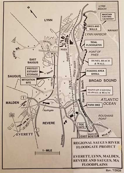
The Corps of Engineers New England Division investigated solutions to the flooding problems in the study area caused by the Blizzard of 1978 when 3100 buildings were flooded and subsequent storms. The study was conducted with 5 Steering Committees over 4 years ('85-'90, $2.6 million) by the Saugus River and Tributaries Flood Damage Reduction Study which recommended the Regional Project (see "Documents"), This option #3 includes a Floodgate structure at the mouth of the Saugus River with a 100-foot-wide Navigation Gate and eight (8) 50-foot wide Flushing Gates, designed to provide safe passage for navigation and the natural tide levels and flushing in the 1,650-acre tidal Estuary landward of the gates. The Estuary would be purchased and managed to protect its flood water storage and environmental resources (see "Photos" for Rumney Marsh video).  The gates would be tied to 3.1 miles of shorefront improvements along Lynn Harbor, Point of Pines and the Revere Beach Reservation. The 1.5-mile Nahant Causeway would be protected and maintained since it significantly reduces wave action in Lynn Harbor, mouth of the Saugus River and at Point of Pines.   The project would protect 5,000 buildings, 8,000 housing units, 10,000 residents, 20,000 employees and 400,000 commuters in the region against the worst coastal storm likely to occur, the Standard Project Northeaster (SPN), and against the historical 1-foot rise in sea level, estimated damages at $ 1.3 billion.           

The Secretary of Environmental Affairs after the NEPA/MEPA review provided a positive Certificate (see "Documents"), the Commonwealth then supported it, and the US Congress authorized the Project for construction, which proceeded into final design at $6 million over 3 years (see "Documents").  Then in the fall of 1993 a new Secretary of Environmental Affairs, an environmental activist from Rhode Island, was opposed to construction along the Massachusetts coast and the project was stopped, and since it has been de-authorized.   

78_Flood.jpeg

ACCELERATED SEA LEVEL RISE & NEW STUDY

Renewed interest in the Project by the communities due to frequent coastal flooding and accelerated sea level rise resulted in the Boston North Shore Feasibility Study which was authorized by the President on 23 Dec 2022 to investigate the flooding and ecosystem needs for the Study area. The study name has been changed to the "Saugus River Coastal Storm Risk Management Feasibility Study" in order to avoid confusion with other Boston studies.  The initial planning of the Regional Project and other options were based only on the historical rate of sea level rise of one (1) foot, and only subjectively addressed the potential impact of higher rates of sea level rise.  By 2020 accelerated sea level rise was universally accepted and the Corps of Engineers adopted a rate of rise of 5-feet by 2100 for planning projects and Coastal Zone Management (CZM) a high of 7.8-feet by then.  The impacts of accelerated sea level rise have a significant impact on the region and project and were therefore re-evaluated by the Corps' original Project Manager following 2020. He used completed investigations and the forecasted and adopted rates of sea level rise by the Corps of Engineers and by CZM for the year 2100.  The potential damages to the estimated 6,000 to 7,000+ buildings in the higher SPN floodplain would be in the billions of dollars impacting 100,000 residents and employees and half a million commuters, or nearly a million folks affected. 

The Regional Project would still include the Floodgate structure and improvements along Lynn Harbor but raised for a 5-foot (or 8-foot) sea level rise by 2100. Building sand dunes and beaches at Point of Pines, along Revere Beach, and possibly along the Nahant Causeway using the abandoned I-95 sand should effectively reduce the SPN overtopping based on detailed studies.  The use of this sand could remove 4,900 feet of the I-95 embankment, restore 40 acres of ecosystem habitat buried by the embankment, and restore flushing to the upper 500 acres of the estuary.  Breaching and removing the I-95 embankment to restore the wetlands is a major goal of resource agencies.  The preliminary cost of the Regional Floodgate Project for SPN protection with a 5-foot rise in sea level would be about $340 million initially at 2026 price levels.  As sea levels rise 5- to 8-feet by 2100, it would become necessary to close the floodgates more often reaching about 50 per month at 6 hours each by 2090. These closures would interfere with navigation, cause significant impacts to the passage and lifestyle of fish, retard the growth of the estuary limiting sand deposits, and cause a number of different water quality impacts in the estuary. 

HOW TO REDUCE FLOODGATE CLOSURES

In order to reduce the impacts from closing floodgates, three options can be considered: (1) construct low walls or dikes about 2-3 feet high initially along 25 miles of shore and rivers to raise the start of damages, thus reduce closures back to 3 to 40 per year with each foot of sea level rise;  (2) modify the navigation gate to a Navigation Lock which would allow boats to pass through at any ocean tide level; or (3)  Combine low walls along the shoreline to raise the start of damages to maintain closures to 3 to 40 per year, and construct a narrower navigation lock to improve passage during all closures.

Option#1-- LOW WALLS TO REDUCE CLOSURES--This may be a preferred option since it has no significant impact on fisheries, wetlands, or water quality but with minor impact on navigation.  The impact on navigation are the delays or inconveniences waiting up to 3-4 hours for gates to open, and danger of getting caught oceanside with a pending storm.   The walls would cause problems to residents and businesses especially if walls exceed 5-feet in height.  Also, issues include closures for access and maintaining tide gates on drainage systems, as well as potential pumping stations.  The first time a 1-foot rise in sea level would begin to cause significant closures is 2040 shortly after the project could be built.  Thus, to reduce closures back to 3 per year, the initial wall construction around the shorefront should occur, raising walls or dikes about 2-3 feet. This is reflected in the above First Cost. Subsequent raisings would occur about 2060, 2075 and 2090 reaching a total wall height about 5-feet.  The cost to raise the shorefront is roughly estimated at $140 million in phases.

Option#2-- NAVIGATION LOCK 

A second option considered was a Navigation Lock, shown below, which would modify the single Navigation Gate mentioned above in the Floodgate structure.  The Navigation Lock would allow for boat passage at any tide level.  The Navigation Lock would still be combined with eight (8) flushing gates to maintain tidal flushing in the estuary.   This plan would eliminate the need for any walls around the estuary or along the rivers' shorelines as sea levels rise. As with the original plan, protecting and maintaining the natural flushing and tide levels in the estuary, plus providing for flood water storage (between El. 7-8) from runoff when gates are closed would still be required.  All gates including both gates on the Lock and the eight (8) 50-foot-wide flushing gates would remain open as ocean tides remain below elevation 7 feet NGVD.  At this level, river and estuary water levels would be below the start of damages at El. 8-feet NGVD, and all wetlands would be inundated naturally at and below El. 6 feet NGVD.  As ocean tides rise above 7 ft. NGVD, all gates would close and the lock would be operated.  The problems are that as the closures continue to increase, there would be significant impacts on environmental resources including fisheries, water quality and wetland growth in the estuary.  The cost is roughly estimated at $100 million to increase to a 100-foot-wide navigation lock.

Option#3-- LOW WALLS & NAVIGATION LOCK 

A third option is a combination of both low walls and a narrower navigation lock. A narrower lock, less than 100-feet wide, may be all that's required due to changed design criteria.  Also, smaller gates in the Lock would reduce the cost of the lock, as compared to the 100-foot-wide navigation gate in the first two options.  The 100-foot-wide navigation gate was originally designed to accommodate safe passage for the oil barge which delivered to General Electric, and that the General Edwards Bridge opening was 100-feet.  GE discontinued use of barges in favor of road transportation years ago.  The design criteria would now include recreation boats, generally 8.5-feet wide, and lobster boats likely 10-feet or less, thus, a navigation lock about 30-feet wide may be acceptable.  Whether a lock is justified would in part be dependent on the severity of the inconvenience in option#1.  Of, course, a 30-foot-wide navigation gate should be considered in Option 1 as well. If the navigation gate or Lock gates are reduced to 30 or 50-feet-wide, at least one additional 50-foot-wde flushing gate would need to be added with possibly no significant change in the project cost.

Lock_P.jpeg

GATE CLOSURES

The number of times either the Navigation Gate or the Navigation Lock Gates and Flushing Gates would be closed to prevent damages would increase with sea level rise.  For example: by 2030 with 0.7-foot rise, closures would only be about 3 times a month averaging 2.5 hours each; by 2050 with 1.6-foot rise, closing 10 times per month at 4 hours each; in 2070 with 2.7-foot rise, 23 closures at 5 hours each; and, then by 2090 with 4.2-foot rise, 49 closures per month at 6 hours each.  There would be significant impacts on navigation unless one of the options is adopted. The information learned from the initial design of floodgates, which included physical and numerical models, could be used to help design a Navigation Lock. 


Model_B.jpeg


HOW NAVIGATION LOCK & FLUSHING GATES OPERATE

A Navigation Lock is a concrete chamber with gates on both the ocean end and on the river end of the chamber.  If a recreation or lobster boat wants to leave the riverside to enter the ocean, water level in the chamber is drained to river levels. The riverside gate then opens, and the boat enters the chamber, The river gate then closes and valves open to let ocean water fill the chamber.  Once the chamber water levels and boat reach ocean water levels, the ocean gate opens for the boat to leave. The reverse happens for a boat to leave the ocean and enter the river. 

When ocean tide levels drop to elevation 7-feet NGVD, all navigation lock gates and flushing gates open for the Estuary and rivers to drain as the ocean tides drop to low water levels.  The gates remain open until ocean levels rise back to elevation 7, then all gates close and the lock then operates for boat passage.  While all gates are open, boats can pass freely through the Lock chamber.  By closing gates when ocean levels are above elevation 7, damages to properties, starting at elevation 8, are prevented, and the Estuary wetlands up to elevation 6 are totally submerged.

OPTION #1 & #2 WITHOUT FLOODGATES

Without any Floodgates, the Region would need to be protected against the Standard Project Northeaster in 2100 with 5-feet of sea level rise by Option#1.  The plan would require using walls and dikes up to 12 feet high along roads and yards for most of the 25-miles of estuary shorefronts.  The cost would likely be at a much higher cost than the Floodgate Project, likely exceeding $500 million ('23 pl,) for walls, dikes and pumping stations.  Option#2, a non-structural plan, to raise all buildings up to 12-feet high would cost considerably more than the Floodgate Project while roads and yards would be continually or frequently under water.  The cost to totally evacuate the floodplain with the removal of all buildings would be in the order of $10-15 billion or more which would cause extreme hardship to folks in the region.


Show Your Support

Please contact your community representatives with letters and emails of support or concerns.

Directory of Local Reps


Definitions & Abbreviations